

Omdurman Through the Times
The production team for this episode are:
Research and Producer: Mai Abusalih
Presenter: Azza Mohamed
Script: Husam Hilali and Mai Abusalih
Music: Zain Records
Narration and audio mixing: Tariq Suliman
Project Manager: Zainab Gaafar
Equipment and technical assistance: elMastaba TV
Recording studio: Rift Digital Lab
Accompanying Essay
Written by: Rayan Khalil – Translated by: Mohammed Awad – Edited by: Mai Abusalih
“I am Omdurman, I Am the Nation
Its voice, and its feelings
I am the foundation
I… the one who brought together the dispersed
Melded north with south
Poured east into west
And planted kindness on the roads
May I remain the pride of our homelands”
Abdullah Mohammed Zain
“From Futaih, through the creek to Al Maghalig
From the highlands of Aburof to the lowlands
A stride, my lord, barefoot and clean-shaven
Following the route of the Tram”
Khalil Farah
Omdurman has always been known as the national city, the melting pot that comprises all ethnicities, tribes, geographies and cultures, despite the internal political and economic differences. The opinions seem to vary between supporters and critics of this national identity it represents, or maybe was intended to. In our exploration of the urban history of the city, we will discuss the settings and circumstances that have contributed to the foundation of the city, taking in consideration the issue of migration and its impact on the urban fabric, as one of the most important factors, if not the most important at all, that contributed to the making of today’s Omdurman. The issue of migration will not be discussed in isolation from all the political, economic, and social factors that influenced or was influenced by the city throughout the different time periods.
***
A first time visitor of Omdurman will unmistakable take notice of the particularity of the site, as it lays between the arid western desert that extends as far as the eye can see, and the Nile, the source of life, as it slowly flows northwards toward the Mediterranean, and with its vast skies and rock-strewn ground. All these factors have shaped it into an excellent location, chosen carefully for erecting the camp of Al-Mahdi in his war against the Turco-Egyptian colonization. Nevertheless, these characteristics became ideal for the creation of a city distinguished with its unique history and culture.
The history of settlement in Omdurman highlights the importance of the location, as the excavations around Abu Anja Creek revealed remains that date back to the Lower Paleolithic era,1 and ever since, the area has remained inhabited by different groups of peoples throughout time. However, Omdurman as we know it today might have been founded by mere chance, as it was originally established as a camp for the armies of Al-Mahdi. Following that, we cannot say that the development of the city that happened afterwards was by mere chance as well, as the planning processes of the city were intentional, including the natural and spontaneous nature of the city’s architecture.
Muhammad Ahmad Al-Mahdi is a very intruiging and controversial character. He had a deep faith that he was “the Mahdi” (the rightly guided one), which greatly motivated him to launch his revolutionary movement. He set Prophet Muhammad (PBUH) as his role model which can be observed in the various similarities that exist between the characters of Al-Mahdi and Prophet Muhammad. Understanding the relation between these two figures will aid in comprehending the objectives of Al-Mahdi’s message and the establishment of the Mahdist State later. Al-Mahdi’s objective was to free the lands of the Muslims and the Sudanese, and to continue to “liberating” other states –such as Egypt- similar to the first message of Islam. One of the most important stories in the history of Omdurman that displays the mirroring between Al-Mahdi and Prophet Muhammad is how he chose the location of his house, as he left the matter to his horse until it stood, and that is how the location was decided. His house was made of mud, and following his death, he was buried there and a domed shrine was built above it in that same location where it remains to this day.2
Al-Mahdi left Ar-Rahad and headed towards Khartoum in August 1884, after ordering his followers to march to the east to free the capital city –Khartoum– from the colonizers.3 A great number of people responded to his call and a mass migration began that marked the beginning of the migration towards Omdurman. Omdurman’s sanctity for the Mahdi and his supporters could be recognized in the numerous names that were given to the city, such as Al-Buq’ah, Al-Buq’ah Al-Tahira (the Immaculate Spot) and Dar Al-Hijrah (the Land of Migration), the latter was engraved on the coins made during his reign. In addition to that existed the military advantages, as this spontaneous area had turned into a huge camp as Al-Mahdi’s supporters flocked towards that area and built houses with straw, leather and logs,4 then the city came to life.
Al-Mahdi’s wars against the Turco-Egyptian colonial rule in Sudan was crowned by liberating Khartoum in January 1885.5 However, Al-Mahdi died shortly after moving to Omdurman, and Al-Khalifa Abdullahi –his successor– ruled after him. Al-Khalifa’s reign witnessed the writing of a new history for Omdurman, starting from the moment Al-Khalifa announced Omdurman as the capital city for the Mahdist state. So how did the city grow over such a short period of time to spread over an area of more than 20 square miles?
In May 1885, Al-Khalifa ordered the evacuation of Khartoum and all its residents were to relocate to Omdurman.7 His aim was to eradicate any competition to his new capital city, thus began the destruction of the buildings of Khartoum, as their building materials were dismantled and moved to Omdurman to build new houses there.8 The fusion of different ethnic groups and cultures became a signature of Mahdist Omdurman as the city contained representatives of all Sudanese tribes that coexisted with Egyptians, Indians, Mecca Arabs, Syrians, Greeks, Italians, Turks, Ethiopians, Jews, in addition to groups of West African origins, such as Fulani, Borno, and Borgu peoples. The population of Mahdist Omdurman was estimated to be over 150,000,9 and some speculate that it even reached 400,000.10
The policies of Al-Khalifa required the settlement of as many tribal groups near him as possible, as he needed a huge military force at hand, not only to conquer other states, but also to protect the borders of his city that was surrounded with dangers from all directions. Al-Khalifa turned Omdurman to a city that adopted Khartoum’s former functions as the administrative and bureaucratic center, carrying out the various administrative and military functions of the state.11
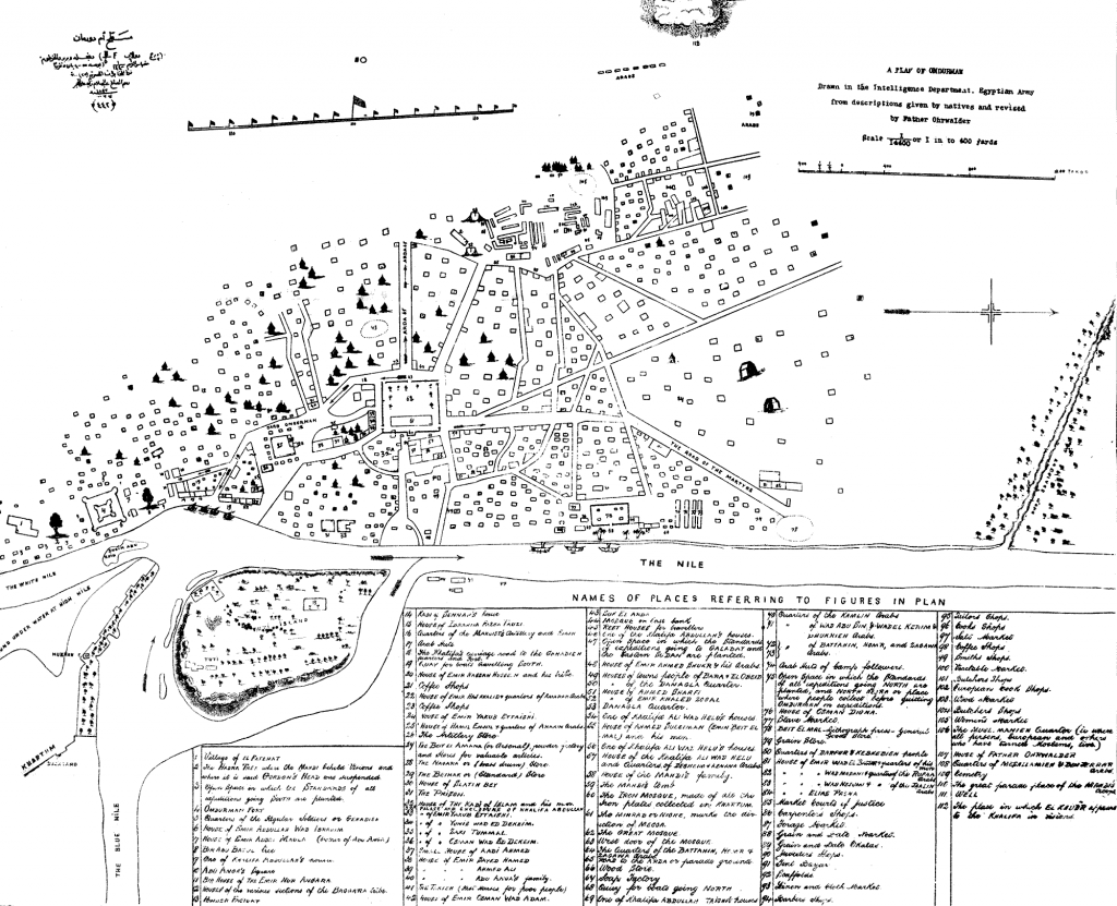
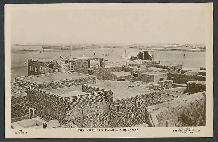
Omdurman began to slowly form according to the strategies of Al-Khalifa, as he was the mastermind behind the city’s planning decisions that turned the scattered villages –which previously comprised Omdurman– into the capital city of his state. This planning process resulted in the creation of the main roads and yards, the market, the mosque, the barracks and other facilities in the city.12 The construction materials utilized were chosen to emphasized the power of Al-Khalifa, as the red bricks seized from the houses of the Turks in Khartoum were used, with the help of skilled engineers and technicians, to build the domed shrine of Al-Mahdi and the quarters of Al-Khalifa.13 Also, the center of the city, which consisted of the official facilities –beside the house of Al-Khalifa and the houses of his guards and family– was surrounded by a great stone wall. Some parts of this wall remain till this day, as it’s construction took almost as many years as the Mahdist state remained in power.14
Between the years 1885 and 1898, the residential areas around Omdurman began to form in an Arab-Islamic style, with vast interior yards (hosh) as a distinctive characteristic. The city followed an organic traditional style that is labyrinth-like and quite difficult to understand, as Al-Khalifa built Omdurman in a network-like style that resembles the religious voids in classical Islamic cities. This spontaneous nature to the city can be noticed in the seemingly disorganized growth of the social fabric of its population, which follows social norms and traditions that follow the principles of vernacular architecture.16
The Salafist method of Al-Khalifa and his animosity towards Sufi sects was reflected on architecture, as he prohibited any form of ornaments, except for Quranic verses. The Nubian style of house with its ornamented facades, for example, didn’t find a place in the mono-cultural Mahdist Omdurman, despite the settlement of Nubians in the city.17 In contrast to the houses of Al-Khalifa with their fortified materials, the houses of Mahdist Omdurman were mostly simple, as the houses of Nilotic peoples were built of fragile materials, such as straw and mud, that being the reason why not much of them remained. Also, the people of nomadic tribes from the west, due to their lifestyle, built semi-permanent houses that also got destroyed with time.18
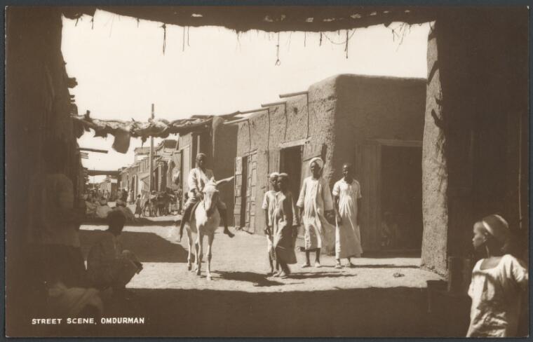
Omdurman had very narrow streets and closed alleys with a distinctive characteristic of being intimate and private. People got around the city walking and rode donkeys, horses, or carts as means of transportation between houses and neighborhoods, which impacted the planning and organic design of the road network.20
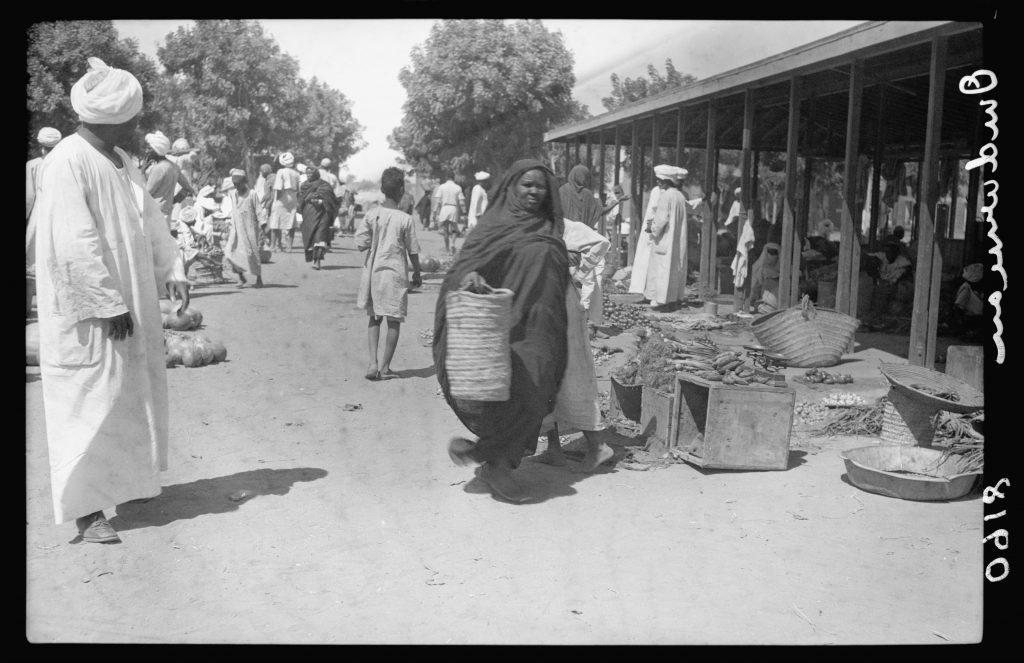
The main urban element of Omdurman was the market; in fact, the establishment of Omdurman Market boosted trade movement in the city, as the small seasonal markets that mainly depended on agricultural products turned into a permanent market in the era of Al-Khalifa. It also became a destination for the different Sudanese groups and tribes, so it attracted more people from the north, south, west and east. It also attracted merchants and skilled craftsmen from neighboring countries.21
Hajj caravans, traveling all the way from West Africa, had to stop at Omdurman Market, and it became their regular route. Also merchants arrived from Egypt and India and settled in Omdurman so they can work in its market.22 The river traffic was also very active because of the boat manufacturing industry that was popular at the time, so Omdurman became the destination of many tribes that lived on the banks of Blue Nile, White Nile, and River Nile. Most of the roads in old Omdurman, and especially in the northwestern side, led to the Market. Because of these factors, Omdurman Market became a key pillar for the city, and the focal point of intersection that drew people from all directions.23
Travelers from West Africa used to depart heading eastwards to Mecca. They embarked on their journey usually without enough funds to sustain their travel expenses, therefore they stayed and worked in places along their route in order to afford their journey. Omdurman, which was already on their pilgrimage route to Mecca,25 welcomed and sheltered them, although the Mahdist state and Al-Khalifa regularly recruited them in his army.26
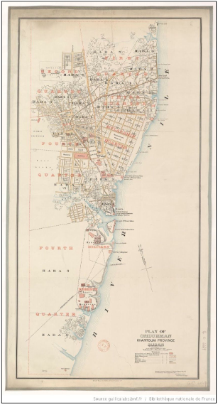
***
The newly formed Mahdist state faced many battles against different states, as it was threatened on its borders with both Egypt and Ethiopia, in addition to having internal conflicts. In order to strengthen and increase his armies, and because of his distrust towards the other tribes that were against his succession and sovereignty, Al-Khalifa ordered the tribes of Ta’aisha and Baggara to forcefully migrate from Darfur to Omdurman. This decision had a huge impact on the economic and political state of Omdurman, and perhaps the country in its entirety.
It is important to note that the Ta’aisha and Baggara are nomads who worked in agriculture or cattle grazing, but by forcibly displacing them to Omdurman, Al-Khalifa turned them from a productive group for the state to soldiers in his army. On their way through Kordofan, they consumed their sorghum stock, and when they reached Omdurman became a privileged elite. Their status and kinship to Al-Khalifa saw that they were provided with all types of supplies and foods, which impacted the state’s reserve. Their migration coincided with a year of very low harvest, due to the droughts in the past season. Because of these conditions, the country underwent one of its worst famines, the famine of “the year 6” (1306/1890).27
The failure of the Mahdist state to relieve the famine that hit its citizens due to the militarization and the calls for Jihad, put the state in a dilemma. The state was completely unable to meet the needs of its population as well as maintain it’s war economy which was imposed on it since its inception.28 The economic policy of the state, the boycott of Egypt, and the decrease of trade movement were all factors that worsened the situation. Al-Khalifa did not foresee the impact of his policies on his economically weak state. Also, the migration of Ta’aisha and Baggara had great political and economic consequences, as the citizens of Omdurman, particularly those of Nilotic origins (Awlad Al-Bahar) and relatives of Al-Mahdi –who thought they were more entitled to become successors of Al-Mahdi– did not see any reason to be welcoming of the newcomers, as Al-Khalifa didn’t even try to disguise his dependence on his kin (Awlad AlGharib) and used them to suppress the opposition to his rule and by forming a new personal military force.29
***
Although plenty of women worked in the market of the city to the extent that they had an entire section dedicated to them, there is general ambiguity in how women lived their lives in Mahdist Omdurman. Women’s presence in the city wasn’t sufficiently documented, as the Mahdist state had policies that required them to stay at home, and these policies reflected in the residential architecture in old Omdurman. For example, we can look at “Al-Naffaj”, which is a passage that connects the houses of the families in Omdurman, as an architectural element that encouraged women stay at home, thus avoiding the need to go out in the streets.
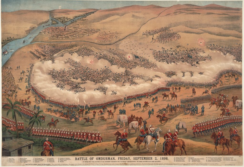
It is interesting that at times Omdurman was considered a “Women’s City,” particularly because the men had to go to war for long periods of time, which revived the women’s role in trade and crafts in the market. After the bloody Karari Battle (Battle of Omdurman), where 11,000 men of Al-Khalifa’s army died, Omdurman was almost entirely under women’s rule. However, the british policies changed that later and only dealt with men, as they did not acknowledge women’s rule even in their homeland. These circumstances did not deter the women’s movement in Omdurman, which continued to grow and flourish.31
***
After The Mahdist state was conquered by the Anglo-Egyptian invasion in 1898, many of the tribes migrated back to their lands, following the colonial policy to “empty the capital area of useless mouths.”33 Due to these policies, towns in Kordofan and Al-Jazirah flourished once more, as many of their inhabitants were formerly forced to stay in Omdurman by Al-Khalifa. Some were forced out of the city after the battle of Karari, while others stayed in Omdurman and made it their home. On the other bank of the Nile, Khartoum, the colonial capital city, for the second time, arose from its rubble. However, it’s new map did not include national citizens, who resided at the outskirts, which did not bother the colonizers at all.34
The planning process of Khartoum was primarily concerned with foreign elites, who resided in the Nile-neighboring areas in the north and center of the city. The colonial presence was prolific in the city’s diagonal roads that were overlaid on a gridiron pattern in an imitation of the Union Jack, the national flag of the United Kingdom.36 These diagonal roads were created first and foremost for security, as they eased the military control over the city against any kind of resistance, meanwhile the locals were left to inhabit shantytowns beyond the railroad bridge and Al-Sunut Forest.37 Khartoum in this manner was designed and planned to resemble a European city, while Omdurman was ignored and disregarded by the British as a discriminatory policy and became with –its organic nature– the primitive model that broke out of control, contrasting the modernity of Khartoum, at least in the eyes of colonizers. Paradoxically, Khartoum was seen as an ugly artificial city by Europeans who were more fascinated by Omdurman in true orientalist fashion and showed interest in visiting the city because of the “authentic” and “exotic” experience it offered.38
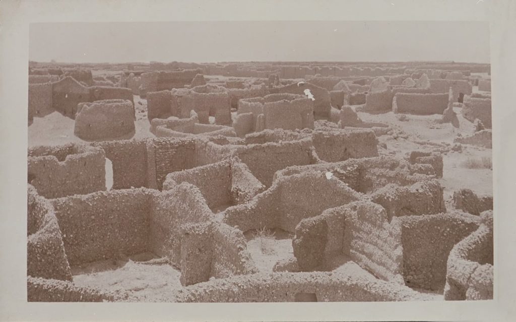
When the British finally began to think of planning Omdurman which –despite the out-migrations from the city– maintained an enormous population (43,000 in the year 1910). This proved to be quite difficult as the British couldn’t organize the meandering labyrinthine alleyways of the city. Also, Omdurmanis were adamant in holding onto their rights as owners of property, forcing the British to take a more conservative route than that of Khartoum.40 Henceforth, most of the city replanning concerned the road network as well as the neighborhoods that weren’t heavily populated or those that were demolished during the Anglo-Egyptian invasion.41 One such example is the old Mulazmeen quarter that was destroyed in the battle of Karari, which was then replanned and laid out decades later.
After assigning the British James Bramble as inspector of Omdurman, he converted the House of Al-Khalifa into a museum in 1928 and added a few exhibitions from the Mahdist era. That marked the beginning of the modernization process of the cultural identity of Omdurman.43 In that era, the British worked on diversifying activities as cultural, educational, health, and recreational activities were introduced to Omdurman, such as the Grand Mosque, Omdurman’s General Hospital and the Teacher’s Institute.44 The older location of Omdurman Radio was also constructed in 1940 in the Post Office Buildings,45 in addition to Bramble Cinema and National Cinema.46
Since Khartoum was constructed as a colonial city during that period, Omdurman was considered the national capital, which transformed it into the nationalists refuge as well as anyone who wished to rebel against colonialist Khartoum.48 Therefore during the Condominium rule, the headquarters of the Graduates General Congress, and later the headquarters of most of the national political parties were established in Omdurman.49 Nearby, Omdurman’s Market flourished50 after it had undergone a process of expansion and replanned of its road network as well as the reorganization of the market itself.51 Omdurman’s market famously contained important cafes, such as George Mashriqi, Wad Al-Agha, Al-Zeibaq, and Yousuf Al-Faki Cafés.52 These cafes were considered the beating heart of the city with their literary and artistic forums that hosted artists and poets –especially Haqeeba poets– and it became the center for an intellectual and political revolution in the past century; the national movement.53
Colonial policies were restrictive on mass migrations, therefore after Sudan’s independence and the lifting of these restrictions, there was considerable accerlation in the rate of migration.54 Omdurman continued to expand after Sudan’s independence, leading to the emergence of new neighborhoods, such as Al-Thawrat, Um Badda, Al-Muhandiseen, Al-Rawda, and Madinat Al-Neel, which with their vast extensions became cities in their own right.55 However, the city’s expansion became increasingly more rapid in the following decades that the planning process changed and the city entered a new era of urbanization.
| Year | Population |
| 1909 | 42,779 |
| 1956 | 113,600 |
| 1973 | 299,399 |
| 1983 | 526,284 |
| 1993 | 1,271,403 |
| 2008 | 2,395,159 |
Waves of migration from rural areas to Omdurman due to the attraction of the capital were motivated mostly by economic reasons. However, the largest development in the pattern of migration to the capital occurred when internally displaced persons (IDPs) fled to the capital and settled on the outskirts of the city. There are numerous drivers of displacement in Sudan that forced people to flee to the capital. The country faced many natural disasters in the beginning of the 1980s, including droughts and famines in the west and the east, which forced thousands to flee internally to the capital city. 120,000 persons have fled to Khartoum from Darfur and Kordofan alone.57 In parallel, the second civil war which took place between 1983 and 2005, forced many people to flee to Khartoum and Omdurman to escape war.58 Also the conflict in Darfur, which began in 2003, forced more people to be displaced.59 Because of these reasons, Sudan was ranked as the country with the highest number of IDPs in the world in the 1990s and 2000s, and in the year 2005, the number of IDPs reached its peak with 6.1 million IDPs in the country.60 Despite the decrease of this number through the years, Sudan’s ranking remains high in the list with 2 million IDPs.61
These enormous numbers of IDPs that arrived in the capital –in what is referred to as “the black belt”– faced denial and indifference as well as outright hostility from successive governments since the 1980s. IDPs were viewed as a threat to political stability, a burden to the economy, and a source of social and cultural tension, all of which created hardships for them in securing housing and services.62 President Nimeri (1969-1985) went as far as enforcing the (Kesha) policy: “the displaced who trekked to Khartoum from western and southern Sudan were randomly picked up by security forces and relocated either back to their places of origin or to production sites in the districts of the central region.”63
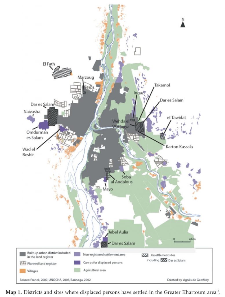
In late 1990s and early 2000s, Inqaz government (1989-2019) started some initiatives to fight poverty and marginalization, and huge numbers of low income citizens were integrated in working class districts around Khartoum, but these initiatives were interrupted by frequent random and inhumane evacuations which resulted in many human rights complaints.65
Most IDPs settled in informal housing (slums) on the outskirts of cities. Planning initiatives since the 1990s were limited to the provision of lands on the outskirts of cities, and they were ostensibly designed to decrease the pressure on the overpopulated slums, so their houses were destroyed by security forces, and they were forcibly moved to new areas known as IDP camps. Such as Dar Al-Salam and Wad Al-Bashir camps in Omdurman.66 The urban researcher Dr. Hanaa Mutasim conducted interviews with IDPs who settled in Dar Al-Salam camp and found out that most of them used to live in Al-Gamayir neighborhood in the center of Omdurman. When Dar Al-Salam camp was built, the government destroyed their houses without providing any compensations, and Al-Gamayir was re-planned into first class land plots and was named Al-Thawra, Block 6).67
Those who flee to the city are the ones who suffer the most from the lack of services and inaccessibility to livelihoods, because authorities always try to place them in the margins, out of the sight of city inhabitants. This painful reality of these camps in Omdurman was reflected in the names given by the locals who live in them. Of the examples of these names is Al-Salam camp, which is also named “Jabarona”68 (meaning they forced us). The government tried to change these names in an attempt to conceal the truth, for example the camp named “Zagalona” (meaning we were thrown out), was renamed to be “Al-Tharwa 15.”69
While the government has tried to enable IDPs to own land when it established Al-Fatih resettlement sites 40km north of Omdurman, these sites have significantly decreased the quality of life for IDPs since they are very far from the city center and provide no access to services and livelihoods for them.70 Due to these difficult circumstances, IDPs were forced to leave Al-Fatih and be displaced once more.
We must view IDP camps, relocation sites, and even informal settlements in a critical eye and how the issues of the margin are transported into the city. It’s important to consider the city’s position and acknowledgement to IDPs, since through their different architectures, have become inseparable parts of the formation of our capital, Khartoum. It is without a doubt that urbanization is a global phenomenon today, and because of that, cities must be able to predict, accommodate and be resilient towards this growth particularly towards vulnerable groups who have been displaced, marginalized and forced into cruel circumstances that encloses them in a continuous cycle of poverty and displacement.
***
The ethnic and cultural homogeneity of Omdurman that was created during the colonial era was a result of painful experiences that the inhabitants of the city have experienced. The city had its fair share of tribal tensions that rattled the city between Al-Khalifa and his relatives from the western Sudan tribes, and the relatives of Al-Mahdi and the Nilotic tribes. The fall of the Mahdist state and the painful defeat in the Karari Battle, however, united the citizens of Omdurman against colonial rule, propelling the city into an era of social cohesion and integration. These factors led to launching the national movement inorder to liberate the country from under the colonizer’s rule, thus giving birth to Omdurman’s identity as Sudan’s microcosm, the nationalists’ refuge.
However, if Omdurman is indeed seen as a model of national integration and the melting pot that shaped the Sudanese national identity through the prevailing cultural movement which started during the colonial period, some consider that this statement is not accurate, and in fact misleading. The culture of Omdurman has rejected and alienated other groups and individuals with the argument that they are not true Omdurmanis.71 Some even claim that the many migrations in the 1970s and 1980s, was the beginning of losing the image of “national identity.”
In fact, this statement calls for questioning this image; did it truly reflect the national integration that allegedly envelopes the entirety of Sudan? Professor Idris Salim says that Omdurmanis will say yes, because the image of Omdurman as Sudan’s microcosm exists only in their minds.72
That national identity of Omdurman has certainly been put to the test since the 1980s and onwards. “I am Omdurman, I am Sudan” now has new meanings, as Sudan since its independence, hasn’t witnessed stability in all of its parts that were marginalized at the expense of developing the center. These displaced people have brought their grievances and destabilized Khartoum’s -and therefore, Omdurman’s- manufactured image of stability and social harmony. In fact, the image of Omdurman as microcosm of Sudan did not become a reality until it actually included people from all parts of Sudan, who were once again marginalized at city level in the midst of social elimination by native Omdurmanis.
In the face of this new challenge to the Omdurmani identity, there is no common enemy that unites Omdurmanis, as the enemy has become one another once more, similar to that of the Mahdist state. It is without a doubt that the best and ideal solution for the issue of displacement is through finding radical solutions at the root causes. However, it seems that the current complexity of the political and economic situation in Sudan makes it more challenging to achieve radical solutions in the near future. In the midst of these complexities, one may argue that one of the few options available is to address the issues of IDPs on a city level, if at the very least by changing the state’s marginalizing and discriminatory policies against them. Omdurman today is presented with a unique opportunity, since it’s image as Sudan’s microcosm has the capacity to be utilized as a realistic example to achieve social cohesion and real change, instead of utilizing its image for othering people. If Omdurman becomes able to achieve true equality on all social, cultural and economic aspects to all of its inhabitants in the future, perhaps that might carve the path towards finding actual solutions to the problems that have divided Sudan since its independence.
1 Lobban, Richard, Robert S. Kramer, and Carolyn Fluehr-Lobban, Historical Dictionary of Sudan. Lanham, Md: Scarecrow Press, 2002. Print. P. 337.
2 Abu, Salim M. I, Tarikh Al Khartoum. Khartoum: Dar Al Irchad, 1971. Print. P. 85.
3 Ibid. p. 71.
4 Ibid. p. 85.
5 Ibid. p. 71.
6 A Plan of Omdurman. Drawn in the Intelligence Department, Egyptian Army from descriptions given by natives and revised by Father Ohrwalder. 1890. Map. https://www.gutenberg.org/files/32875/32875-h/32875-h.htm#plan
7 Ibid. p. 81.
8 Stevenson, R. C. “OLD KHARTOUM, 1821-1885.” Sudan Notes and Records, vol. 47, 1966, p. 33. JSTOR, www.jstor.org/stable/44947302.
9 Rehfisch, F. “A SKETCH OF THE EARLY HISTORY OF OMDURMAN.” Sudan Notes and Records, vol. 45. 1964, p. 42-43. JSTOR, www.jstor.org/stable/41716857.
10 Abu, Salim M. I. Tarikh Al Khartoum, Khartoum: Dar Al Irchad, 1971. Print. P. 86.
11 Ibid.
12 http://drhashimk.com/2بیوت–أمدرمان–العهد–المهدوى-/
13 Ibid.
14 Abu, Salim M. I. Tarikh Al Khartoum, Khartoum: Dar Al Irchad, 1971. Print. P. 86-87.
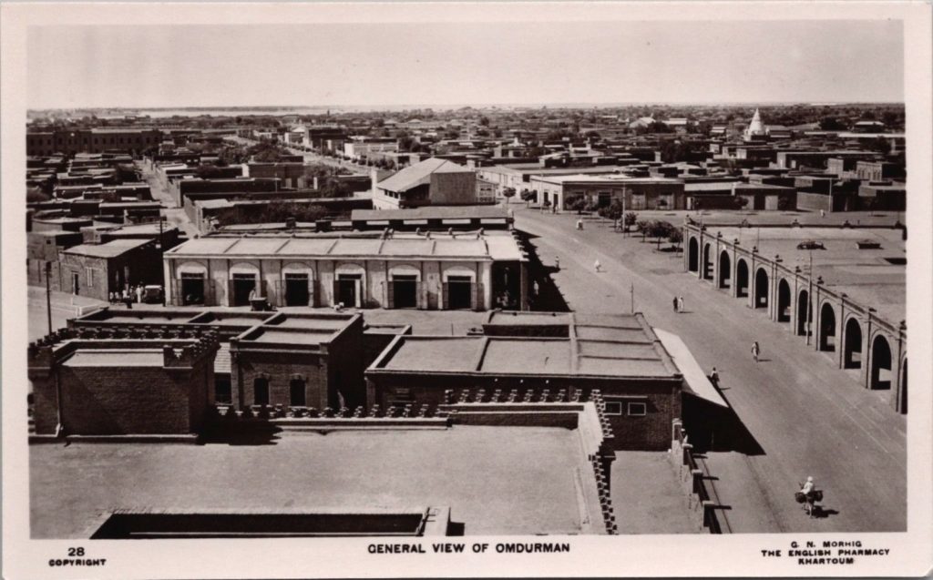
15 Morhig, G. N. General View of Omdurman. Khartoum: The English Pharmacy. Postcard. https://www.ebay.com/itm/Sudan-Old-Real-Photo-Postcard-The-Khalifas-Palace-Omdurman-Khartoum-Camp-Tents/383716198750?hash=item595744895e:g:ZvAAAOSwZDlfW7Cg
16 Ahmad, Adil Mustafa. (1992). The Neighborhoods of Khartoum. Habitat International, 16(4), p. 27-45.
17 http://drhashimk.com/بيوت–أمدرمان–العهد–المهدوي-2/
18 Ibid.
19 Sudan Railways. Street scene, Omdurman. Atbara, Sudan Railways, 1939. Web. 6 August 2020 http://nla.gov.au/nla.obj-160227480
20 A Study Of Dynamics Of Omdurman Market (Souk Omdurman) http://khartoumspace.uofk.edu/handle/123456789/10383
21 Ibid.
22 ElHassan, Idris S. Telephone interview. 14 June 2020.
23 Ibid.
24 Ahmed, Chanfi. “1 Hijra on the Sudan Road (Ṭarīq al-Sūdān)”. West African ʿulamāʾ and Salafism in Mecca and Medina. Leiden, The Netherlands: Brill, 2015. https://doi.org/10.1163/9789004291942_003 Web.
25 Abu-Manga, Al-Amin. “Pilgrimage Travels and their Social Effect on Nilotic Sudan”. 2008. https://www.researchgate.net/publication/260424501_rhlat_alhj_watharha_alajtmayt_walaqtsadyt_fy_swdan_wady_alnyl_Pilgrimage_Travels_and_their_Social_and_Economical_Effect_on_Nilotic_Sudan/citations
26 Lecocq, Baz. “The Hajj from West Africa: a Form of Global Historical Perspective (19th and 20th Centuries)”. African Diaspora 5.2: 187-214. https://doi.org/10.1163/18725457-12341237
27 Weiss, H. “The 1889-90 Famine and the Mahdiyya in the Sudan: An Attempt to Implement the Principles of an Islamic Economy”. Studia Orientalia Electronica, Vol. 85, May 2014, –. 163-92, https://journal.fi/store/article/view/44006
28 Ibid.
29 Okoth, Assa. A History of Africa: African Societies and the Establishment of Colonial Rule, 1800-1915. Vol. 1. East African Publishers, 2006. P. 273. Available online: https://books.google.com/books?id=6knAMseFPpIC&printsec=frontcover&source=gbs_ge_summary_r&cad=0#v=onepage&q=khalifa&f=false
30 Matson Photo Service, photographer. Suddan. Omdurman. The Market Street. 1936. Photograph. Retrieved from the Library of Congress. www.loc.gov/item/2019708141
31 El-Hassan, Idris Salim. “Old Omdurman and National Integration: The Socio-Historical Roots of Social Exclusion.” 2015. https://www.academia.edu/16173182/Idris_Omdurman_Final_Submission_1
32 Sutherland, A., “Battle of Omdurman, Friday, September 2, 1898. No. 1: In order that the positions of the different regiments may be readily distinguished, the home uniforms have been retained ” (1898).Prints, Drawings and Watercolors from the Anne S.K. Brown Military Collection. Brown DigitalRepository. Brown University Library. https://repository.library.brown.edu/studio/item/bdr:238446/
33 Lobban, Richard, Robert S. Kramer, and Carolyn Fluehr-Lobban. Historical Dictionary of the Sudan.Lanham, Md: Scarecrow Press, 2002. Print. p. 446.
34 Abu, Salim M. I. Tarikh Al Khartoum. Khartoum: Dar Al Irchad, 1971. Print p. 167.
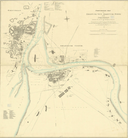
35 Stanton, E. A. Provisional map of Khartoum city: Khartoum north and Omdurman / compiled for useof the Khartoum Mudiria by Lieut. Colonel E.A. Stanton, Governor Khartoum Province. Khartoum,Sudan 1906. https://collections.lib.uwm.edu/digital/collection/agdm/id/984
36 El Kheir, O. “Omdurman and Khartoum, coexisting disparities.” (2017). https://www.academia.edu/9894736/Omdurman_and_Khartoum_coexisting_disparities
37 Ibid.
38 Knowledge Production in and on Africa. Austria, LIT, 2016. p. 241. https://books.google.com/books?hl=en&lr=&id=iqKLDwAAQBAJ&oi=fnd&pg=PA235&dq=Omdurman+colonial&ots=f7IG7tjun5&sig=xOP50Er5aJNFvMuxZWOo8jkyZg#v=onepage&q=omdurman%20colonial&f=false
39 Henderson, K.D.D. Ruins of Mulazmin Quarter. Omdurman, Sudan. Durham University Library. 1900/1920. Photograph. http://reed.dur.ac.uk/xtf/view?docId=ark/32150_s18p58pd02s.xml#qxj-2523
40 W.H. McLean, The Planning of Khartoum and Omdurman. Town Planning Conference, London), and Royal Institute of British Architects. Town Planning Conference, London, 10-15 October, 1910: Transactions. London: Royal Institute of British Architects, 1910. https://hdl.handle.net/2027/pst.000033919294?urlappend=%3Bseq=667
41 Ibid.
42 Plan of Omdurman, Khartoum province, Sudan 1/10.000. Compiled under the Direction of El Miralai Pearson Bey, R. E. at the Khartoum Town Survey Office 1911 / H. C. Cansick, del. [1914]. https://www.europeana.eu/en/item/9200517/ark__12148_btv1b53063413c
43 Adam, Ahmed. (2018). Museums in Sudan, History, Current Situation and Challenges.
44 A Study Of Dynamics Of Omdurman Market (Souk Omdurman) http://khartoumspace.uofk.edu/handle/123456789/10383
45 http://mininfo.gov.sd/الهیئة–العامة–للاذاعة–القومیة/
46 https://www.sudaress.com/alsahafa/12913
47 Morhig, G. N. General View of Omdurman. Khartoum: The English Pharmacy. Postcard. https://www.ebay.com/itm/General-View-of-Omdurman-Sudan-Africa-Unused-RPPC-Real-Photo-Postcard-E19-/233530967904
48 Abu, Salim M. I. Tarikh Al Khartoum. Khartoum: Dar Al Irchad, 1971. Print. p. 167.
49 El-Hassan, Idris Salim. “Old Omdurman and national integration: The socio-historical roots of social exclusion.” 2015. https://www.academia.edu/16173182/Idris_Omdurman_Final_Submission_1
50 http://www.sudanile.com/99987
51 A Study Of Dynamics Of Omdurman Market (Souk Omdurman) http://khartoumspace.uofk.edu/handle/123456789/10383
52 A Documentation Program about Omdurman Market https://www.youtube.com/watch?v=50FZoYoRnKE
53 Omdurman Market Reeks of Sudan’s History http://www.alkhaleej.ae/supplements/page/7591274a-c700-4c42-9b4d-b44c3bc0f2b9
54 Pantuliano, Sara, et al. “City limits: Urbanisation and vulnerability in Sudan-Khartoum case study.” (2011). https://www.odi.org/sites/odi.org.uk/files/odi-assets/publications-opinion-files/6520.pdf
55 https://www.alquds.co.uk/أمدرمان–السودانیة–العاصمة–الوطنیة–وأ/
56 Ibrahim, Mohamed Babiker. “The Unique and Innovative Contribution of Omdurman City to National Unity and Nation Building in Sudan from 1900 to the 1980s.” The Arab World Geographer 21.1 (2018):1-19.
57 Pantuliano, Sara, et al. “City limits: Urbanisation and vulnerability in Sudan-Khartoum case study.”(2011). https://www.odi.org/sites/odi.org.uk/files/odi-assets/publications-opinion-files/6520.pdf
58 Ibid.
59 Ibid.
60 https://www.bpb.de/gesellschaft/migration/laenderprofile/307860/internal-displacement-in-sudan
61 Ibid.
62 Eltigani, Eltigani E. T. War and Drought in Sudan: Essays on Population Displacement. Gainesville: University Press of Florida, 1995.
63 Ibid.
64 De Geoffroy, A. “Fleeing war and relocating to the urban fringe – issues and actors: the cases of Khartoum and Bogotá.” International Review of the Red Cross, 91(875), p. 515. (2009). https://www.researchgate.net/publication/231841484_Fleeing_war_and_relocating_to_the_urban_fringe_-_issues_and_actors_the_cases_of_Khartoum_and_Bogota
65 Pantuliano, Sara, et al. “City limits: Urbanisation and vulnerability in Sudan-Khartoum case study.”(2011). https://www.odi.org/sites/odi.org.uk/files/odi-assets/publications-opinion-files/6520.pdf
66 Ibid.
67 Motasim, Hanaa. “The Perception of Urbanity in a condition of Displacement Internally Displaced Persons (IDPs) in Sudan.” Respect, Sudanese Journal for Human Rights’ Culture and Issues of Cultural Diversity, 7 (2008).
68 Assal Munzoul, A. M. “Displaced Persons in Khartoum: Current Realities and Post-war Scenarios.” Cairo: the Population Council (2004). https://www.popcouncil.org/uploads/pdfs/displaced.pdf
69 Pantuliano, Sara, et al. “City limits: Urbanisation and vulnerability in Sudan-Khartoum case study.”(2011). https://www.odi.org/sites/odi.org.uk/files/odi-assets/publications-opinion-files/6520.pdf
70 Assal, Munzoul. Conflict-Induced Migration in Sudan and Post-Referendum Challenges. 2011. Available online: https://core.ac.uk/download/pdf/45680249.pdf
71 El-Hassan, Idris Salim. “Old Omdurman and national integration: The socio-historical roots of social exclusion.” 2015. https://www.academia.edu/16173182/Idris_Omdurman_Final_Submission_1
72 ElHassan, Idris S. Telephone interview. 14 June 2020.